Engine idling in the middle of the desert, we contemplate the pockmarked metal sign in front of us. Military Range, it declares, adding the instruction that civilian vehicles are to keep to the main road. Which leaves us with a question–what is the definition, out here, of a “main road”? Off to the side, a double hump of volcano-pokey-up-things (“cinder cones,” my husband Keoni helpfully supplied, when I described them thus) stand out from the flat plain like a pair of breast implants, and the road winding around to the top is the one we’re itching to turn onto. “Well…” Keoni reasons aloud, “it’s just da one road up, yeah?” I nod. “So… I t’ink dat’s da main road, brah.” With a wink and a wicked grin, he puts the car back in gear.
For some people, taking a scenic byway IS going “off the main road”–but we’ve found that even a Byway is a road from which we’re going to wander. Take this desert detour, for example–today’s purported destination is the Old U.S. Highway 30 (now quaintly called the Oregon Trail Byway), but before we even hit the jumping-off point (a mere forty freeway-miles from home) we found a roadside marker that sent us tripping off on this tangent. We’ll get to US 30 when we get to it. And praise the Lord and Apple Apps for the half-dozen map-apps on my iPad, which allow us to take a look at what roads we’re on–since that situation so seldom synchs with what roads we expected to traverse.
We were chatting on that first bit of freeway-drive about the laudable improvement to Idaho rest stops (at least the ones along the interstate–elsewhere you might still find outhouses), so although our morning coffee hadn’t yet hit, we pulled into the first rest stop for an evaluative look. Cheery blue-roofed building, green grassy picnic space (an oasis, truly, in the desert here), historical information, and sparkling facilities–in some neighborhoods you couldn’t find a park this pleasant. It was the Oregon Trail historical marker there that tipped us off our planned route–a mention of a view the wagon trains witnessed “just a mile beyond this point” (though of course it didn’t say in which direction).
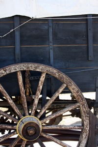
So we pulled into the Boise Stage Stop at the next exit–indeed, the modern-day version of a stage-stop, where dozens upon dozens of semi trucks line up in the evening, sleeping beasts gathering for the next day’s assault on the interstate. The historical stopping point for the Overland Stage Line stood a few miles south, but beneath its flashing reader-board the Boise Stage Stop does boast some picturesque relics–a covered wagon (“Prairie Schooner” decked full-sail in canvas, and entirely vintage–except, perhaps for metal grommets in the canvas cover) and a manure spreader (perhaps on loan from our uber-Republican State Legislature).
I was forcibly struck by the narrowness of the wagon bed–a paltry four feet across, maybe a dozen feet in length–and tried to imagine cramming this small space with all the tools necessary to begin a new life in an unknown place. Farming implements, tools for building a homestead (and repairing a wagon in transit), dry goods to last for months, iron cookware and metal dishes, rifles and traps, water barrels, perhaps an heirloom piece of furniture, schoolbooks for children… I packed more shit than this four-by-twelve space when I left for college, and the campus was right across town from my parents’ house (not to mention WalMart and Pizza Hut). In my gradeschool days (growing up a handful of miles off the Oregon Trail in Eastern Idaho), I churned out reams of wagon-train drawings, and I realize now that I’d always imagined the wagons to be bigger. I’m sure I was abetted in that error by the wide-framed farm wagons I saw on “Little House on the Prairie” (the one TV show I was allowed to watch once I graduated from “Sesame Street”), but as I consider the challenges of crossing an unpaved continent, I imagine this narrow little number might have been necessary in places.
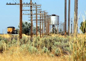
Instead of getting back onto the freeway, we headed south on the Mayfield-Orchard road, wending our way between sunflower-studded wheat fields and military signage, stopping to gather a rainbow of broken glass along the roadside. Evidently the remains of the Corder Station stage stop are somewhere out there, crumbling into a pasture among the cricket-percussion rattling the dry brush, but it’s the Oregon Shortline Railroad (which eventually rendered the stage lines obsolete) which we found instead. Keoni prowled the tracks picking up rusted railroad spikes while I circled the steam-engine water tower, still shining proud despite its splintering roof. A huge white-visaged barn owl launched itself from under the tower, dipped its wings at us as if in salute, and scattered an explosion of pigeons from the roof before sailing out of sight.
A word here about na ‘aumakua… Most cultures (perhaps barring the skeptical-secular American) enjoy relationships with protector-spirits. Names vary–totem, guardian, ancestor, angel; in Hawai’ian culture the protective ancestor-spirit is the ‘aumakua, a word which could be translated to mean “personal- or family-god.” A Hawai’ian family will have its own ‘aumakua, manifest in the form of an animal of the islands–Keoni’s family belongs to Mano, the shark. As his tutu pa (grandfather) Kamuela told him when he was small, “When you see Mano, dat mean one good t’ing or one bad t’ing gonna happen.” Keoni’s irreverent response (which earned him a cuff on the ear): “Well, Tutu Pa, dat depends wheddah you on top da watah or underneat‘!”
In addition to the family’s ‘aumakua, an individual may have a personal ‘aumakua. You don’t go looking for one, and you don’t choose one–the ‘aumakua makes itself known to you, and if you’re the kind of person who pays attention to things, you might recognize the relationship. (Not unlike prayer, I find–God sends us all kinds of notes, and we only recognize his answers if we’re paying attention.) Feeling myself comfortably under the protection of Mano, by virtue now of being part of the Ka’anapu-Kanai-Tyler family and honoring their traditions, I hadn’t thought to look further–but pue’o, the owl, came unexpectedly tapping for me, and any owl-encounter now is significant punctuation in a journey.
 In the beams supporting the water tower we spotted our owl’s launching-point, an oversized nest built of thumb-thick twigs, nestled against an upright. I wondered aloud about climbing up with the camera (not dignified, given the summer dress I’m wearing today, but not difficult either), but the backside of the structure sported a “No Trespassing” sign. Keoni must have seen the speculative gleam still in my eye–he reminded me that I won’t be off probation for 10 more days and should probably behave myself, Wise Spoilsport that he is.
We drove for a while alongside the tracks (definitely off-map–even our most detailed diagram didn’t show a road there) admiring the multicolored glass insulators decorating the aging wooden power poles. “I always wanted to find one of those,” Keoni remarked, just moments before slowing at the side of the road and asking me to open my door. There it was, green and bell-shaped and humming with the history of transmitted telegraph messages and (that other outdated technology) telephone lines. A Union Pacific engine (diesel now, of course, rather than steam) passed us pulling a string of colorfully graffitied cargo cars–modern petroglyphs, we joked.
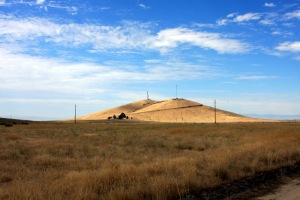
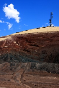
On this flat volcanic plain the cinder cones were an easy and irresistible landmark–we angled toward them along unmarked roads, and (having made our determination about the permissibility of the road upward), we’re now climbing in low gear, to the soundtrack of tinny-crunchy cinder under the tires and the scrape of sage brushing the undercarriage. The sun has been flirting with us all morning behind scudding clouds, painting the landscape in dramatic swaths of sunlight and shadow. From the top of Cinder Butte, the plain stretches around us in all directions–black and burned-looking, mostly, but punctuated with Irridescent greens of irrigated fields. An 1866 trail-traveler, Julius Merrill, journaled here, at about this same time of year: “We again come in sight of Snake River Valley and that black desolate plain. Our road now strikes the Salt Lake Stage Road. On every little creek where there is sufficient water for irrigation there are ranches, most taken up this season, and a few vegetables are raised.” His post-script, a celebration of communication lines: “At a stage station [Corder, just below us] we first heard of the fall of Atlanta and Fort Morgan, and that General Morgan had been killed. It has been a long time since we heard any war news and, as might be expected, were quite jolly over such good news.” The radio towers perched atop the butte beside us carry news of different civil and world wars, but–along with the weather-worn posts lining the rail-tracks–bear testament to the human need to “stay in touch,” by whatever means the human mind invents.
Since our earlier owl didn’t offer to deliver post (no doubt it hasn’t yet read Harry Potter), I feel moved to borrow a different bird, and Tweet my editor with a field report: “Today’s expedition: Old US 30. On the road 4 hrs, not yet to Mtn Home, LOL. Friggin’ AWESOME out here!” Theoretically, Mountain Home is 40 minutes from our doorstep, but The Editor is well aware of our propensity to sidetrack–maybe he’ll have a chuckle while he’s glued to magazine proofs. (I have the best end of this deal, do I not?)
Mountain Home’s Air Force Base seems to extend its influence even to civilian life–on the way into town we see a daycare facility billed as a “Child Training Center.” Start ’em young, I guess. We also pass “Easy Street”–I used to wonder how to find that mythical locale, but didn’t expect to find it in rural Idaho… Here we pick up our planned path, turning onto Old US 30 (commemorated locally by the “Highway 30 Drive-In” burger joint) and cross over the interstate.
I’m fussing with my map, having gotten befuddled by the last road-marker, which pointed three different directions for “US 30,” “US 30,” and “Old Oregon Trail”–but I finally put it aside and simply take in the bigger picture. This path has had so many incarnations, and so many names.
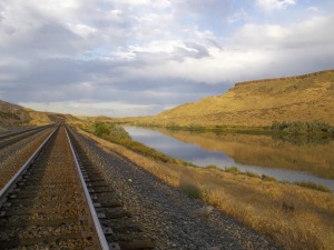
I once had a picture-book of Rome, each photograph of a majestic ruin coupled with a clear sheet whose illustration, when overlaid on the photo, showed how the original had looked all those centuries ago. I’m thinking of this road in a similar way, trying to see not only what’s here now, but what has been here… The Shoshone-Bannock tribes (“Snake” Indians from whom the river takes its name) traveled here–among the earlier-mounted Native Nations, they traveled with horses to gather on the Great Camas Prairie and harvest their staple root; hunted buffalo to the south and east; and traded with other tribes, leaving petroglyph records of their commerce, and rock-chiseled maps of the Snake River Plain.
Then came the trappers and mountain men, following close on the heels of Lewis and Clark’s arduous journey–and behind them those prairie pilgrims, the wagon trains of settlers moving in to stay. In places along their trail you can see the deep rut, wagon-wide and probably shoulder-high to an ox, worn away by the single file of thousands, and a geography professor once told me that in satellite photos the Oregon trail is visible as a swath of non-native plant life, inadvertently seeded by the pioneers passing through. As outposts of “civilization” began to dot the western map, stage lines moved in, followed by railroad tracks laid along the same pathways. Little does the passing freeway-driver know how much the trappers of old affected his current drive-route; the interstate parallels the railroad, which overlaid the stage lines, which co-opted the Oregon trail, which grew from paths scouted by the mountain men.
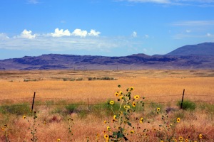
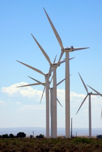
August colors here run to golds and purples–ripe wheat, starburst of sunflowers, violet shadows below the rims of volcanic bluffs and mesas, and the deeper shades of mountains along the north rim of the Snake River Plain. Besides wheat, the “crop” most in evidence along this road is an invisible one; side-by-side with hundred-year-old farmhouses stand rows of white windmills, their blades rotating in concert like the arms of synchronized swimmers. We imagine the harvest here is a good one, a guess based on our own extremely windblown state; Keoni’s tangled mane just broke our plastic hairbrush in two. I’ve given up on mine entirely, focusing instead on the challenge of tilting at windmills, a la Don Quixote, armed with a telephoto lens.
A brush fire has charred one hillside along the road, and we stop to read the historical marker at its base. We’re diverted, though, by the discovery of four coyote skeletons, maybe killed and skinned by a local farmer and left here–the pads and fur of the paws are intact (though scorched), but the rest of the bones have been picked (or burned) clean, spinal columns measuring their segmented lengths against the ashy ground, carnassials and canines gleaming white in empty skulls. After adding a coyote skull to the glass collection in Keoni’s “scavenging basket,” we pause to read the sign for which we’d originally pulled over. It features another journal-entry by an 1845 pioneer, and I’m struck by the universality of the urge to document travels. Before telegraph or phone lines, before blogs and tweets and travel magazines, these hardy tourists detailed their journeys without any expectation of an audience. Yet here we are today, standing beside the road and reading this “blog” from the past.
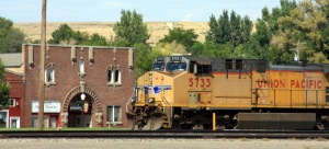
The Byway crosses back to the south side of the freeway at Glenn’s Ferry, a town named for Gus Glenn, a Union soldier who emigrated to Idaho in 1863, building and operating the ferry which hauled the continuous procession of wagons and freighters and stagecoaches across this wide stretch of the Snake River. Main Street (now named Idaho Avenue) is a one-sided affair facing the railroad track with a colorful line-up of painted brick storefronts. A red livery barn (painted with a mural of horses-and-buggy) has been in business for over a hundred years, and even newer businesses occupy historic retail space.
We adhere to a set of Magic Road-Rules when we travel, a list begun in fun and which, like Captain Barbossa’s take on the Pirate Code, “be more like guidelines than actual rules.” Since it’s well past lunch-hour, though, it’s time to put #5 into action: always eat at a locally-owned restaurant. Preferably the type where you might end up chatting with the owner while you eat. We hit the jackpot at Fudge Factory Grill & Ice Cream with an order of Huckleberry Joe (a sloppy-joe style sandwich with huckleberry BBQ sauce), sweet potato fries, and the best potato salad I’ve ever eaten away from home. You can just tell when potato salad is homemade instead of scooped from a pre-ordered bucket, and our server (who does, indeed, turn out to be the owner) confirms that it’s her great-grandmother’s recipe. The clean, bright, and blessedly air-conditioned interior is hung with rodeo photos of her wrangler-grandfather, and she sells huckleberry ice cream, huckleberry honey, and huckleberry BBQ sauce from behind the counter.
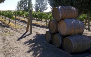
South of the railroad tracks, we follow signs down a road running along the river-bluff to the Carmela winery, its vineyards sprawling around a cheery stone building which can only be described as an architectural mish-mash of “French chateau” and “Italian villa.” Since both of us are recovering alcoholics, we skip the tasting-room and wander instead through the vines and stacked wine-barrels to the flagstone patio overlooking the river. For those who can safely indulge, an umbrella-shaded iron table here looks like the perfect setting to enjoy a chilled glass of Carmela’s white “River’s Mist.”
A little further down the same road lies Three Island Crossing State Park, located at the site where wagons attempted the river before Gus Glenn’s ferry opened for business. Floating the wagons and swimming the livestock, though all too often at the cost of lives and goods when a wagon swamped, gave travelers a promise of a shorter journey than the route continuing along the south bank, as well as more water and better feed for the livestock. Every August the local community re-enacts the crossing here–horses, oxen, wagons, 19th-century clothing and all–in a three day celebration which includes mountain man competitions (tomahawk-tossing & tall tales), chili cook-offs, and a rifle raffle.
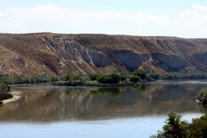
Today, though, the park is quiet. We browse our way through the onsite History & Education Center and walk down to the water’s edge, where a handful of tiny cabins dot a wide lawn sloping down to the riverbank. Having spent six hours in an un-cooled car along dusty roads, we take one look at the glassy green water and resolve to add “swimsuits” to our outing-checklist. The park has considerately chosen this time of day to water, however, so we gleefully stand in the sprinklers until our clothes are drenched and our dusty feet have resumed their usual color.
Thoroughly refreshed, we retrace our steps to Glenn’s Ferry (noting, in passing, the Academy of Equine Dentistry, the log cabin which is Main Street’s garage, and the retired school bus which now serves as a walk-in taco shop) to pick up our US 30 route once again. The highway and railroad curve side-by-side in the space between the river and a pale cliff of siltstone, its layers the color and general appearance of egg-carton cardboard until they crumble under a touch. In the rubble of at the cliff’s foot we squeeze a few fist-sized rocks with our hands, shattering their layers to reveal fossilized outlines of embedded plant-seeds. Add another sheet to the layered-history-map; even river plants from ancient floods can evidently send a pictogram to the future.

The Bonneville flood of fifteen thousand years ago swept through the Snake River Plain when a gigantic inland sea (the dregs of which are now Salt Lake) suddenly burst its bank, sending water roiling across southern Idaho at 15 million cubic feet per second. The flood left behind rounded basalt boulders, which still pebble the landscape like black goosebumps, and whose little brothers Keoni hopes to pick up on this trip for his imu, or barbecue pit. He goes rock-stalking up a hillside beneath a railroad bridge and starts tossing rocks into piles along the road, where I pick them up and play hot-potato with them until I can drop them in the trunk. (Note to self: after “swimsuit,” add “work gloves” to the daytrip-list.) I can see why these are perfect for retaining enough heat to cook a pig, given how hot they are just sitting in the sun.
The community of King Hill, an unincorporated town of a few hundred souls, nestles between the river and the hills, featuring a small post office, an irrigation hub, and a couple intriguingly signed businesses (The Counting Club, with stained-glass puffins on the door, and the Beatnik-evoking Casady Corner) which are sadly closed, leaving our curiosity unsatisfied. We leave King Hill with no more clues about its economy than the numerous haystacks along the road, spray-painted with batch numbers, and the fact that “Git R Done” bull semen is now available from the local 101 Ranch. As we head down US 30 to its next meet-up with the interstate, a roadside billboard standing in a field of basalt boulders reads: “Petrified watermelons! Take one to your mother-in-law.” We’ve read a number of historical markers today; this is our first hysterical marker.
Despite the fact that we’re less than 100 miles from home, we’ve been on the road for ten hours and figure it’s time to get on the freeway and head back. Of course, that resolution lasts exactly as long as it takes us to arrive at Paradise Valley exit, where we wonder if we can reach the edge of the river-gorge via the frontage road we see running beside us. (Post-it note: remember to download a topo map onto the iPad. All my roadmaps are NO help on this question.)
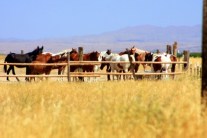
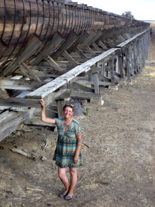
Off we go, and though a “Dead End” sign greets us almost as soon as we hit the frontage road, we figure we’ll at least see it through before we turn around. The road dips below the level of the interstate, and we park the car under a trestle supporting a wooden culvert, constructed like a super-long barrel cut in half. A lonely pair of horses insist on kissing me while I try to photograph it, and when Keoni is done laughing at me, he notices some small puddles beneath the conduit. We had assumed, from its obvious antiquity, that this was no longer part of a working system, but we clamber up the nearby hill to peer into the channel and discover that sure enough, there’s water flowing through at a good clip, and papyrus growing along the banks.
The road right-angles here and disappears into a large drain-pipe. At first glance I’m not even sure it will fit a car, but we drive through without trouble and find ourselves on the other side of the interstate, passing roadsigns that match my map–which leads us to ponder the definition of “dead end” out here. Maybe it’s short-hand code meaning “Cityfolk, don’t come whining if you get your car stuck in a drainpipe.”
Paradise Valley merits its name this evening. Irrigation wheel-lines span the green fields, their sprinklers juggling rainbows in the low-angle light. We’re just on the verge of deciding that this is too lovely an evening to drive on the freeway when a text-message from our teenager rings in, wondering if we’ve gotten lost. He probably wants supper. And for that worthy cause we’re willing to steer onto the fast-track home. He should be glad we’re not relying on telegraph anymore.


Great photos — esp. like the rainbow. I really enjoyed your breezy yet intimate writing style, and share your sense of adventure. Thanks for sharing, Kana.
LikeLike
My thanks to you! We do have fun… ;)
LikeLike
“Off the beaten track” is the ONLY way to go, right?
Awesome post!
LikeLike